


Located in the Northern region, especially in the Benue district, Garoua is the capital of the northern region. With a population of about 600,000 inhabitants (2015), Garoua was created in 1935 by Modibbo Haman Njoundi and become an urban community in 2008. The city is the third most populous in the country and it is the only city crossed by the Benue in Cameroon. Garoua is one of the oldest Cameroonian cities. The main language is Foulfouldé and the Islam is the main religion. Garoua is the hometown of the former Cameroonian president, Ahmadou Ahidjo and as such, the city has benefited from a number of infrastructures including an international airport. Garoua is a pleasant and well-equipped city and the average monthly temperature can change from 26 ° C in August to 40 ° C in March.
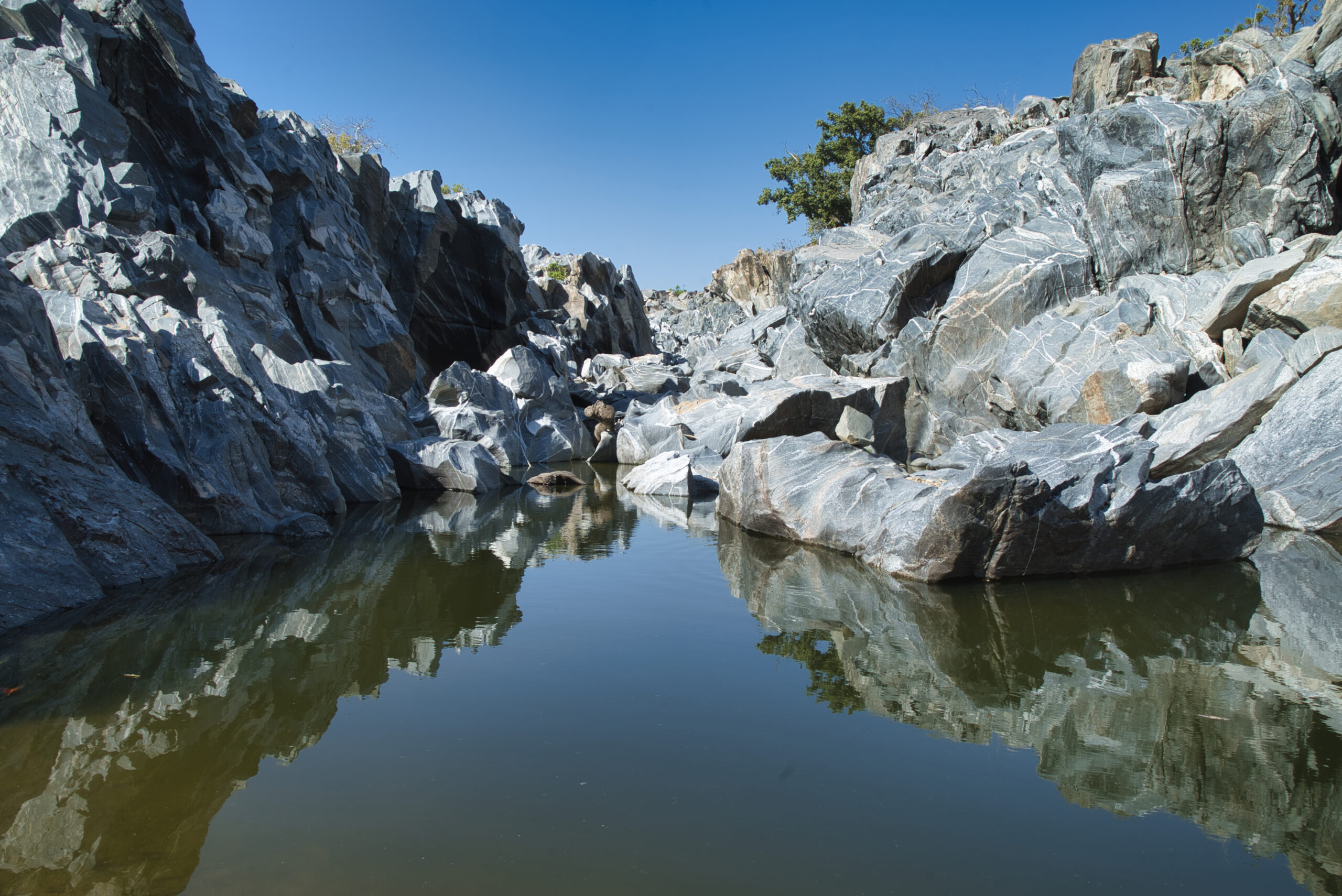
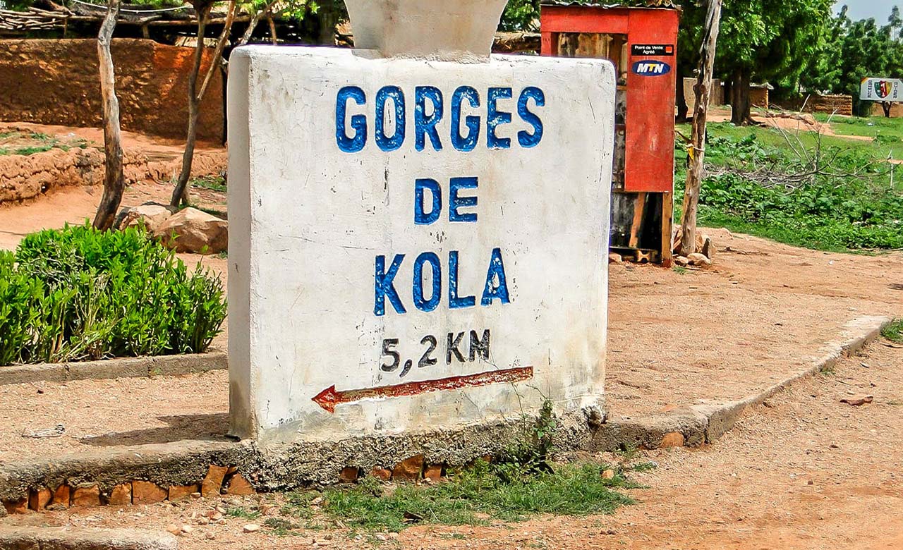
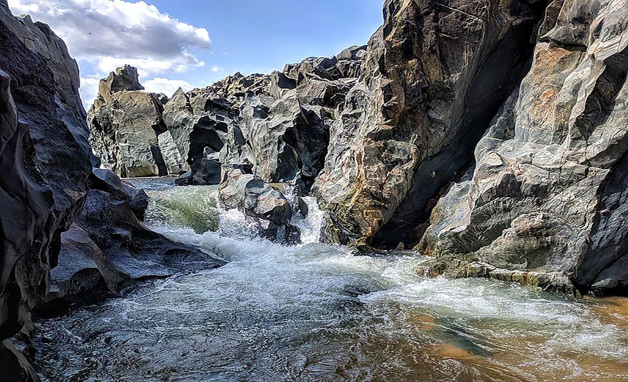
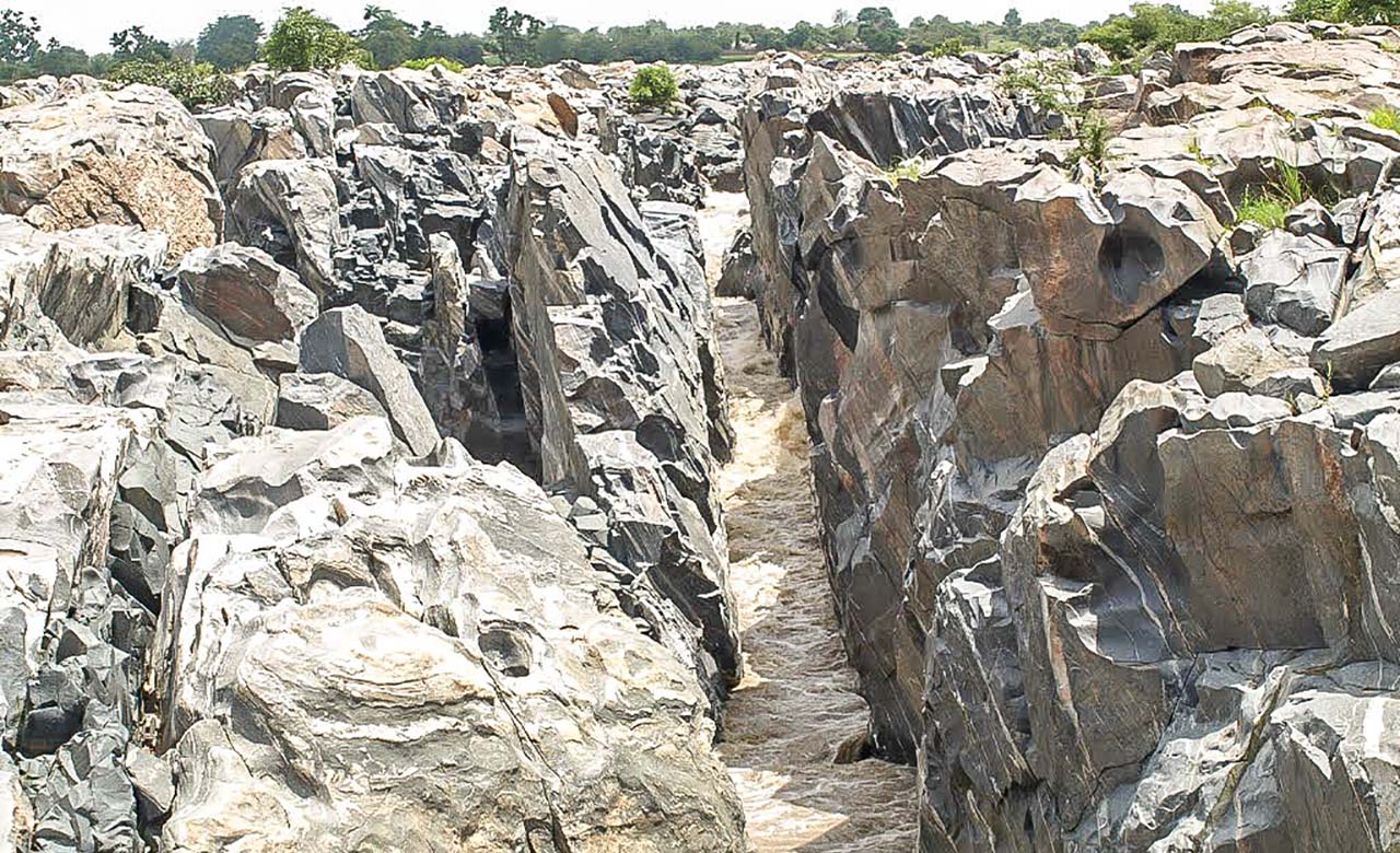
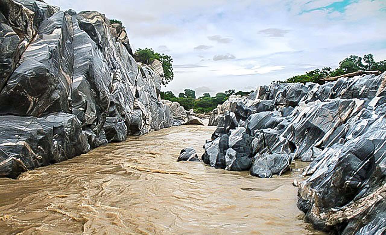
The throat of Kola

Located in the north of Cameroon, nearly 6 km from Guider, the Kola gorges are impressive and magnificent. The Kola Gorge is an exclusively rocky landscape 700 meters long and 200 meters wide. It is one of the most beautiful attractions in the North Cameroon region. Some stones polished by the flow of water, reach 20 m deep. With a total length of about 4 kilometers, they are open to the public and can be visited during low water periods. There are caves, cellars dug by the water and a magnificent waterfall that flows to nearly
twenty meters deep.
Bouba Ndjida National Park

Located in the northern region near the Chadian border, it was created in 1932 as a wildlife reserve and became a national park in 1968. It covers an area of 220,000 ha and is part of the complex of protected areas of the North with the Bénoué and Faro national parks. It adjoins the Sena-Oura National Park in Chad and thus forms the Binational Sena -Bouba-Ndjidda complex. Nearby is the prehistoric site of Managna, it is one of the largest plaques in the world where hundreds of dinosaur tracks can be seen.
Climate
Bouba-Ndjidda National Park enjoys a Sudano-Guinean climate characterized by seasons of equal importance: a six-month rainy season from late April to mid-October and a dry season from November to April during which no rain is observed. The Bouba Ndjidda region receives between 1,000 and 1,250 mm of precipitation per year. The rainiest months are August and September and the annual average temperature is 28 ° C.
Hydrography
Bouba-Ndjidda National Park benefits from a very dense hydrographic network including the Mayo Vaïmba which, unlike other rivers that are seasonal in this part of Cameroon, flows throughout the year. Water is abundant throughout the park and even during the dry season thanks to the bedrock and clay soils which often delay its infiltration, thus ensuring the development of ecological interaction processes between wildlife species and habitats characteristics in this environment.
Wildlife
The park is home to around 24 species of large and medium mammals such as savannah elephants (Loxodonta africana), lions, giraffes, panthers, hyenas, bush pigs and warthogs, hippos, buffaloes, hyenas, baboons, vervets, patas, colobus, aardvarks, servals, wild dogs and jackals which are also very abundantly represented. Rhinos appear to be extinct in Cameroon. The park is also home to around 11 species of antelopes such as the Eland Derby, which is the largest, the most majestic and also the fiercest of African antelopes, Hippotragus, Damaliscus, Buffon’s kob, Defassa Kob, red hartebeest, Reedbuck, harnessed bushbuck, Grimm’s duiker, red-sided duiker, etc.
Avifauna
About 250 species of birds have been identified in the park, 25 of which are restricted to the Sudanese savannah biome. Considering the ornithological richness of the park, it has been declared an area of importance for the conservation of birds. For ornithology enthusiasts, several hundred species of birds alone provide the reasons for a trip. Among them, there are species such as the jabiru or the marabou, the giant Abyssinian hornbill, raptors and scavengers, fish eagles, jugglers, bald vultures, but also smaller species such as the brilliant Abyssinian rollers or the green and scarlet bee-eaters.
Bénoué National Park

Located in the North region, precisely in the Bénoué department and former private hunting estate of the Rey Bouba Lamido, the Benoue National Park is one of the oldest protected areas in Cameroon. It was created in 1932 as a wildlife reserve and became a national park in 1968. It covers an area of 180,000 ha and has been a UNESCO biosphere reserve since 1981. It is part of the Bénoué savannah, a wooded area of humid savannah between the towns of Garoua and Ngaoundéré. The park has a wide frontage on the
Bénoué River, which stretches for more than 100 km thus forming its eastern limit. The elevation of the park ranges from 250 to 760 m above sea level, the highest elevations are characterized by large rock massifs, while the undulating plain and forest characterize the lower sections. The National Park is surrounded by nine specially equipped hunting reserves with a rich and varied fauna. The park and its peripheral zone present a relatively rugged relief with a system of hills separated from each other by plains. The dry and tourist season is around February, it is the period during which the tall grass is burnt, which favors a better view of the fauna from a distance. The level of the river drops, herds of buffaloes, waterbucks, hartebeest, Damaliscus, Buffon cobs, and Derby elands gather around the water points.
The climate
The Benoué National Park enjoys a Sudano-Guinean type climate characterized by seasons of equal importance: a six-month rainy season from late April to mid-October and a dry season from November to April during from which no rain is observed. The region receives between 1,000 and 1,250 mm of precipitation per year. The rainiest months are August and September, the annual average temperature is 28 ° C.
Hydrography
The hydrographic network of the area is essentially made up of the Bénoué which is the only waterway in the region and of which two tributaries, the mayo Mbam and the Na, largely drain the park.
Flora
The habitat of the Bénoué National Park is essentially characterized by wooded meadows. It includes several types of Sudanese woodlands such as forest dominated by Isoberlinia and other woodlands in the south-central, to shorter and more open mixed wooded grasslands in the north, dry Anogeissus forest, riparian forest semi-evergreen and thickets along the Bénoué and its major tributaries.
Fauna
The Benoué Park is home to an extremely rich and varied fauna. It is home to Lions, Elephants, Baboons, guinea pigs, elks, warthogs, crocodiles, buffaloes, Hippotragus, hippos, hyenas, giraffes, panthers, antelopes, guinea pigs several species of primates such as large Cynocephalus, patas, small red monkeys and many other species. The predominant large ungulates in the park are antelopes such as the kob, the western hartebeest, the giant elk, which Africa’s largest antelope as well as the African buffalo. Much less common than in the Faro National Park, the wild dog is also represented. The park is also known for its hippo colonies, hippos and crocodiles are common in the rivers of the park. The park has been recognized since 2005 as a lion conservation unit, in 2011 the lion population was estimated at 200 adult specimens. It is also an area of importance for birds, there are about 306 bird species and 75 species of fish. During the dry season, sandbanks exposed by fluctuating levels of the sandy Bénoué River provide habitat for plovers and other water birds. Common species include the Adamawa Dove, Crocodile Bird, Rufous-throated Bee-eater, Red-winged Gray Warbler, Stony Partridge, and the Violet Turaco.
Faro National Park

Located in the northern region near the border with Nigeria, it was established in 1947 as a wildlife reserve and became a national park in 1980. It covers an area of 330,000 ha and is part of the Sudanese savannah. The park is located at an altitude of between 620 m and 900 m and has a relief made up of plateaus and mountains. The park is surrounded by two aquifer rivers that irrigate the park throughout the year. To the northeast flows the Faro and to the west the Deo, both flow into the Faro in the northern part of the park. The park
has areas classified by BirdLife International as Important Bird Areas. Since its creation, this park has been the subject of constant development and contains most of the animal species that are of great interest to tourism.
Climate
The Faro National Park enjoys a Sudano-Guinean type climate characterized by seasons of equal importance: a six-month rainy season from late April to mid-October and a dry season from November to April during from which no rain is observed. The region receives between 1,000 and 1,250 mm of precipitation per year. The rainiest months are August and September, the annual average temperature is 28 ° C.
Flora
The vegetation, which is similar to that of the Benoué Park, is made up of alternating savannas and wooded areas. This park is rich in diverse species with the main species: isoberlinia doka, burkea africana, combretum spp, anogeissus leicarpus, afzelia africana, cassia spp according to Letouzey (1968), the Faro national park is part of the large group of Sudanese tree savannas.
Fauna
The park has a very diverse birdlife. During a census carried out by BirdLife International, approximately 300 species of birds were inventoried. The avifauna has many species such as the white-crested turaco (Tauraco leucolophus), the Abyssinian roller (Coracias cyanogaster), the bearded barbet (Lybius dubius), Brown-rumped sparrow (Emberiza affinis), the Senegalese tit (Anthoscopus parvulus), red warbler (Drymocichla incana) and the Abyssinian hornbill.The parc is also home to 33 species of mammals including cheetah, lions, elephants, buffaloes, harnessed bushbuck, elephants, rhinos, hippos, hippotragus, giraffes, defassa cobs, Derby elands, damaliscus, warthogs, black rhinoceros (Diceros bicornis), cheetahs, guinea pigs, white rams, hartebeest, horses, several species of reptiles and primates.
Cultural Tourism

The cultural diversity of the northern populations can be seen in the local cuisine, in their varied and unique habitat, in their clothing style, marked by the port of Djellabah for men and women and in their traditional chiefdoms (Lamidats). Among the most prestigious is the Lamidat of Rey Bouba which was built at the beginning of the 19th century under the reign of Lamido Bouba Ndjida.
The Gouma dance

Gouma dance, also known as “topless dance” is a traditional dance of the region. This dance is well-known nationally and internationally and was originally intended for the celebration of the birth of twins, which is considered in this tradition, as an exceptional event. Other traditional festivals and ceremonies are also celebrated in this region, such as traditional October harvest dances that are highly appreciated by visitors and locals alike.
Other Tourist Attractions
In addition to the above-mentioned attractions, the North region offers several other interesting tourist attractions. There are mountains suitable for trekking like the Mountains Atlantika (altitude 1,300 m) which are located near the border with Nigeria. Once at the top, one can observe the beautiful and welcoming Koma population who live in the mountains. They live in a traditional way and feed on hunting, fishing and farming. There are also dams such as the Lagdo dam, magnificent canyons, colorful markets with their flavors, beautiful lakes, artisan centers and traditional chiefdoms (lamidats, sultanates).
